Time for another Blueberry Bog Blog 🙂

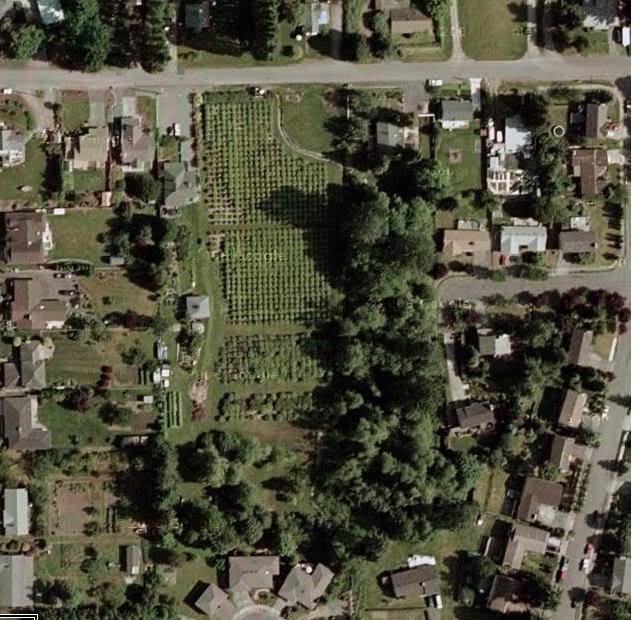
We had a lengthy and interesting discussion at Monday night’s council meeting concerning the Kennydale Blueberry Farm rezone. The owner of the decades-old 3.5 acre farm is ready for retirement, and desires to rezone the property to an R4 or R8 (four to eight units per acre), from its current RC (resource conservation). She also says that the Blueberry plants are dying as a result of the dramatic development all around her farm, and the de-watering of the farm’s natural basin thanks to the city’s new storm-water drainage system.
The city staff, the Planning Commission, and the council’s Planning and Development subcommittee have all recommended R4 zoning for the property, which allows up to four homes per acre on the dry, buildable portion of the property (estimated to be 1.25 acres). Much of the past citizen testimony, however, has been in favor of keeping the zoning at RC, which would not allow subdivision but would allow the existing home, one accessory home, and (as we learned on Monday) several other rural type uses including professional dog kennels, professional stables, and other rural businesses.
But it turns out that the RC zoning would not ever require that the owner delineate the most delicate feature of the property, the peat bog (fen) fed by underground springs, which appears to be thousands of years old and forms the headwaters for Kennydale Creek. In a worst case type scenario, it sounds like RC zoning would allow for a future owner to bulldoze the blueberry plants, and put kennel runs on this peat bog if they were so inclined.
R4 zoning would require wetland delineation, but not until the property owner applied for subdivision. At that time, the wetland peat bog (estimated at 2.25 acres) would be delineated and documented by biologists in a wetland report, marked as a nature zone, and protected against building or any active uses. The remaining dry upland property would accommodate one to three new homes, in addition to the existing home.
Several citizens expressed concern that if the wetland delineation is not done before rezoning, then the character of the property may be altered before the biologists have a chance to survey the wetland. So the council asked the Mayor and the administration to contact the property owners, and see if the city could obtain permission to perform the wetland delineation now, in order to know specifically what the impact of the rezone will be. The report could then be provided to the property owner, and she in turn could share it with potential buyers, to eliminate all unknowns about the wetland when the property changes hands. In addition, council asked the administration to explore whether the owner would be interested in selling the wetland section back to the city, to protect it in perpetuity. ( This is a very common action along creeks and other bodies of water.)
The council has agreed to take up this issue again at Committee of the Whole, in two weeks.


In the Council discussion the other night, it was assumed that the wetland delineation would come with a subdivision application after the property were rezoned.
Actually, I would expect the wetland delineation to be done by the seller right after a zoning change (when there are then lots to be had), but before the property goes up for sale (so the wetland report can be availiable to a buyer). A savvy raw land buyer will not buy raw land in this area without the property owner furnishing a wetland report first (and probably then asking City staff if they will agree with it), because in this regulatory environment it is too easy to get burned. The buyer wants to make sure they are getting what they paid for (e.g. two usable buildable lots, or whatever). A savvy seller will also want the wetland report for similar reasons – they want to get the most $$ for their land that they can, and so they need to be able to prove to a buyer how many lots they can get out of the land to support the asking price. The transaction is for a specific number of lots, not acreage (e.g. each lot is worth $100,000 or whatever). You are buying usable land with a specific lot count, not just a zoned area of acreage, so you need a wetland report to help determine your lot count. The seller wants the maximum number of lots, and the buyer does not want any risk.
The variant on this would be a purchase and sale agreement, where the buyer does not close on the purchase until the wetland report is complete and quite possibly after the City has approved a subdivision. Again, no risk to a smart buyer.
I guess there is still no incentive for the seller to pay for a wetland study at this time (before a zone change), so I’m not sure how useful the above is in the current discussion, but that’s how it will probably go.
Mark Hancock
Kennydale
What’s up,I log on to your new stuff named “Kennydale Blueberry Farm; council rezone discussion – Renton Community Update” like every week.Your writing style is awesome, keep it up! And you can look our website about daily proxy.