This blog post looks a little like a picture book, but is actually an important and easy-to-understand scientific description of where our drinking water comes from.
Renton’s newish Public Works Director, Martin Pastucha, is in over his head when it comes to understanding Renton’s aquifer. The aquifer was extensively studied in 1987, five years prior to my 28-year service on Renton Council, and then again in 2020 (when I was Council President pro-tem), in a 400-page study that built on the 1987 work.
Both of these studies confirm that much of our drinking water comes from many miles up the Cedar River Valley, and that this water can travel half a mile per day in an underground river.
Instead of accepting this reality, Mr. Pastucha has engaged in trying to convince our Mayor, our Council, and the public that it would be impossible for water in our aquifer to travel as far as three miles underground, and therefore asserts that the proposed asphalt plant could never affect our wells.
To help Mr. Pastucha understand our aquifer better, and for all those interested in where our water comes from, I’ve prepared a simple high-level overview using scientific sources.
A fun and easy lesson about where Renton’s water comes from:
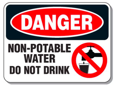
Cedar River water is not drinkable in Renton
First, we need to know that the water in the Cedar River unfortunately contains street and agriculture runoff in Renton. It is not drinkable, and we work to keep it’s clay bed from being punctured so that it does not spill into the deep aquifer. For instance, we’ve ensured pilings for I-405 are not driven through the river bottom and into the aquifer. We work hard to keep it clean enough for wildlife, but not for human consumption.
Renton’s drinking water comes from rain, which falls in our aquifer recharge areas and percolates into our underground aquifer. Renton gets about 40 inches of rain per year.

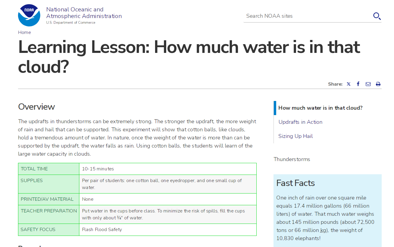
This “fast facts” from the US NOAA reminds us an inch of water over a square mile is 17.4 million gallons
40 inches of rain per year multiplied by 17.4 million gallons per square mile means Renton’s rainstorms drops 696 million gallons per square mile every year.
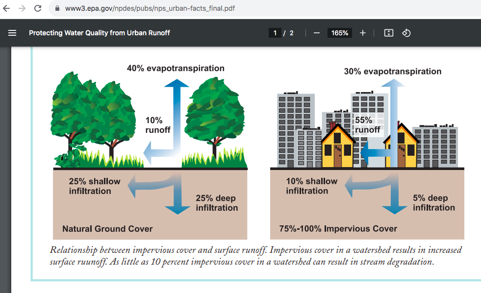
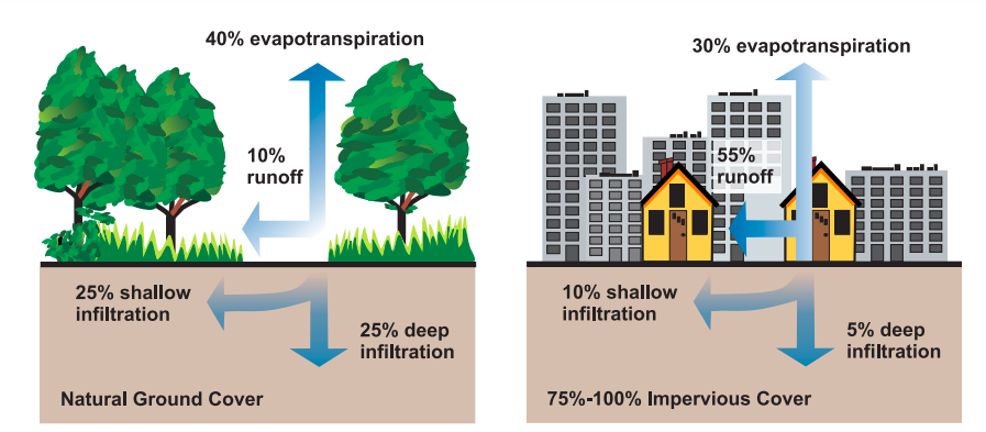
Most of the rain won’t get into Renton’s deep aquifer. This EPA diagram shows. 25 % will typically infiltrate deep aquifers in natural areas, and only 5 % in built areas. I’ll estimate 20% infiltration on average, which would come from land being 80% natural.
Because much of the water evaporates or runs off, only about 20% will reach our aquifer. 696 million gallons per square mile multiplied by 20% = 139 million gallons of water per square mile reaches our aquifer. (Still sounds like a lot!)
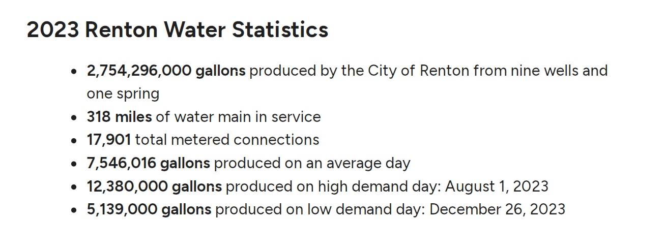
This shows the amount of water pumped by our wells, from Renton’s 2024 Annual Water report
But holy cow! We are a thirsty city! We use 2.754 billion gallons of water per year. On the high demand days, we can pump at a rate of 4.5 billion per year, but we only do this for a short time.
So how many square miles does it take just to quench our average use of 2.754 billions of gallons per year?
2.754 billion gallons per year divided by 139 million gallons per square mile equals 19.81 square miles of recharge area needed for our current city size
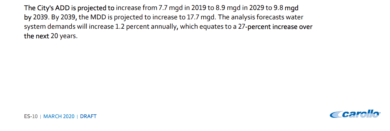
Renton is actively building infrastructure to prepare for a 27 percent increase in daily water demand over the next 20 years
But Renton is actively building for the future, adding new water reservoirs and transmission lines, so that we can meet the predicted demand in 2039, which is 27 percent higher.
19.81 square miles of aquifer recharge area multiplied by 1.27 = 25.15 square miles of recharge area to meet average daily demand
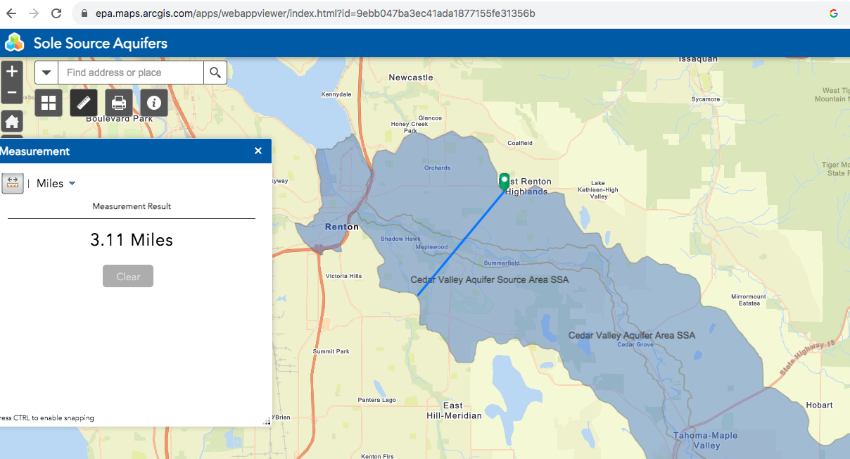
Our aquifer is about 3.11 miles wide near our wells
With an aquifer that is 3.11 miles wide, how much of the valley recharge area do we need to meet our annual water needs?
(25.15 square miles)/ (3.11 miles width) = 8.08 miles long
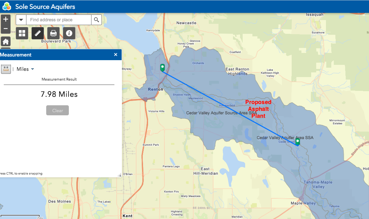
The blue line is 8 miles long. It will take about eight miles of the Cedar Valley Aquifer just to meet Renton’s average daily needs in 2039. (It takes over six miles today)
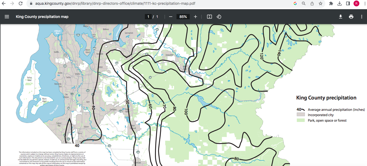
Here’s the EPA’s aquifer map, and I’ve added a measurement showing the eight miles of recharge area needed to meet Renton’s average demand in 15 years. Our demand will be even higher than this on some days, especially if we have a bad fire season.
But wait, some knucklehead put an asphalt plant in the middle of it! I’ll write more about this in a minute.
Much of the water will need to travel five, six, or seven miles to reach Renton’s wells. The distance is not an issue because water can travel quickly through our underground aquifer. It can flow 1/2 mile per day!
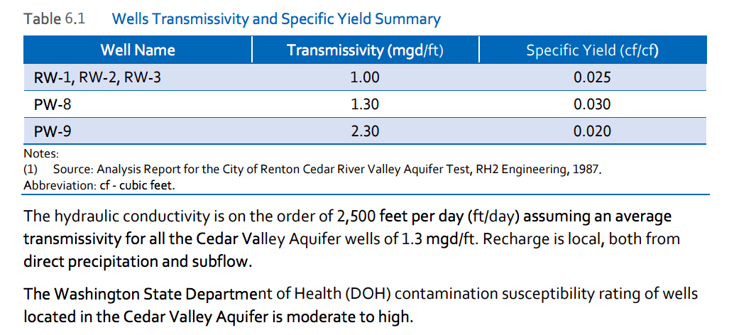
The aquifer hydraulic conductivity, the distance water can travel in a day, is 2,500 feet! But it’s concerning that contamination susceptibility is moderate to high.
These numbers show that hundreds of millions of gallons per year travel under the proposed asphalt plant just to meet today’s water demand, and more than a billion gallons per year will go under the plant when we meet demands in 15 years.
But could toxic runoff injected at the asphalt plant ever reach the billion gallons of water flowing below it? It’s a long way down, right?
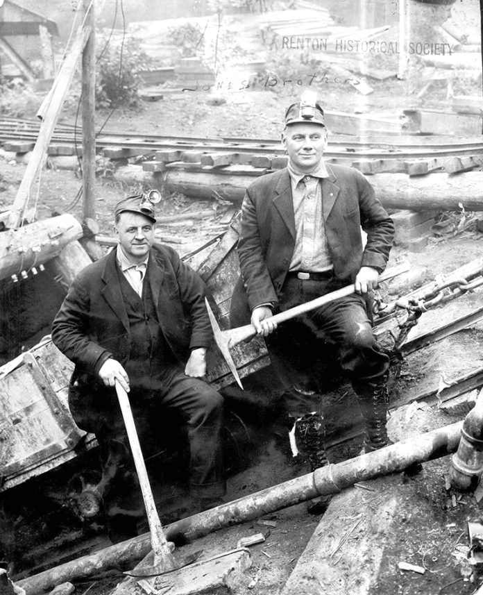
Well, these two gentlemen and their companies built this coal mine 100 years ago, on the exact same property now proposed for an asphalt plant. This is a picture of it.
Guess what they found deep down in their tunnel? If you guessed our underground aquifer, you would be correct.
This excerpt from “Black Diamond – Mining the Memories” by Russell Mowry provides a first hand account of the underground river that they encountered:
“They thought they had the McKay seam there but they did not. They spent a lot of money on that Indian Mine out there on the Cedar River and all they did was hit water. They built two holes in there. That one tunnel they put in there, they ran into water. I was in there about the day they hit the water. Underground rivers running in there about like the Mississippi. There was nothing but sand, you know how water will eat into the sand. It was coming in there so fast they couldn’t stop it.”
This abandoned mining tunnel, and an adjacent tunnel, are still there. The entrances are blocked with about 15 feet of dirt, but toxic runoff injected into the site has a direct drain into our deep aquifer. Scientists hired by the asphalt plant to design the wastewater infiltration system discovered the quick draining nature, unable to ever fill their test pit with water.
For good students, there is now a quiz!
What’s wrong with this statement by the Public Works Director?
As part of the internal environmental review, the Public Works Department evaluated the potential contamination risk to the city’s drinking water sources by the proposed site activities and determined the risk to be relatively low for the following reasons:
- The city’s Maplewood Wells do not pump from the shallow Cedar Valley Aquifer. The Maplewood Wellfield is drilled into the deep production aquifer from approximately 135 to 345 feet below ground surface. The Maplewood Wells are located approximately 3.2 miles from the proposed Asphalt Plant (see the Renton Wells and Asphalt Plant Map).
- The city’s Downtown Wells are located approximately 5 miles away from the proposed Asphalt Plant an even lower risk due to the length of time it would take to travel the 5 miles underground. The sampling wells between the plant and our wells would provide ample notice of a change.
- The Maplewood Aquifer has a low contamination susceptibility rating based on the depth of the wells and the confined layer of clay which acts as a barrier that prevents the downward migration of hazardous chemical spills or other releases of contaminants on the surface.
- The risk to our aquifer is low because of the natural rock and layers of clay that buffers our deep water sources, and the monitoring wells that will provide ample warning to address any issues that could impact them in the future, whether from the asphalt plant or other contamination from vehicles, gas stations, septic systems, etc.
Answer:
The aquifer depth will not protect it since there are abandoned coal tunnels at the site of the asphalt plant. Even without them, water would still infiltrate in this aquifer recharge zone. That’s where Renton gets its water.
Contaminated water can travel the 3.2 mile distance in one week, and hundreds of millions of gallons will pass under the asphalt plant on its way to Renton’s wells.
Contaminated water can travel to downtown in 9 days. Sampling wells will allow wells to be turned off to prevent Renton residents from being poisoned, but it can take years to clean a poisoned well, if it’s possible at all.
The Maplewood Aquifer actually has a MODERATE to HIGH contamination susceptibility per the 2020 study, not a low one as claimed
The “confined layer of clay” (if it even exists) is irrelevant since the miners dug tunnels through it
The natural rock layers are also irrelevant because of the mines
If you were able find one or more of these mistakes, Renton officials need you. Please write to Renton City Council and Renton’s Mayor and ask them to find someone other than Martin Pastucha to manage Renton’s critical aquifer.
Council@rentonwa.gov
Mayor@rentonwa.gov

Renton’s Public Works Director Martin Pastucha has apparently never read Renton’s official wellfield protection studies, and thinks water could not travel underground from the asphalt plant to our wells. Water District 90 has already announced they will have to close their wells due to the asphalt plant.


Recent Comments